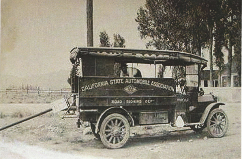
In the early days of automobile travel, various auto associations signed sections of the highway so the new”autoists” could find their way. In the above photos, we see the California Auto Association putting up some of our signs, likely in the early c. 1920s.
The photo above is a CSAA road sign department truck.
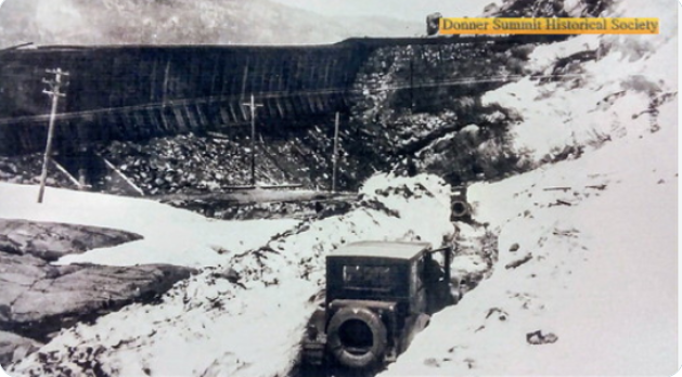
Autos headed east on the Lincoln Highway at Donner Summit c. 1920s. Notice the railroad snow sheds and the subway at the left. The highway wasn’t plowed until the 1930s. Locals in Truckee would hand dig and apply soot (black stuff on snow ) to help early melting.
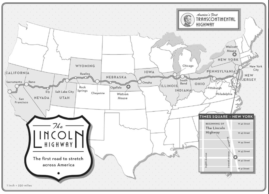
If Amor Towles’s new novel, “Lincoln Highway,” has fired up your wanderlust and you want to learn more about the old road, check out this link to the author’s web page. Full of fantastic photographs and history of the highway. Check out this map which is featured at the beginning of the book.
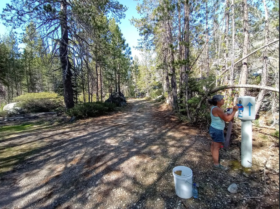
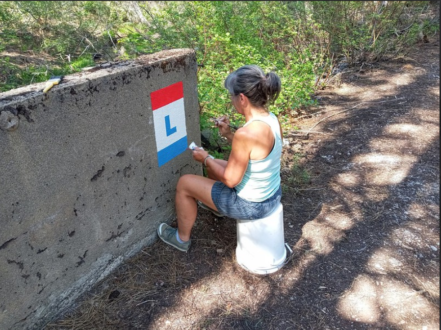
The photo above shows Monica Pitsenberger, California Chapter, touching up a replica marker at Big Bend in the High Sierra of California. The Lincoln Highway Association (LHA) comprises members who are passionate about road history and seeing it preserved. When you join the Association, you will work with your state chapter to encourage markers and signs to be placed along your section of the highway.
Monica is painting an LH “L” on a bridge at Big Bend, CA.
Here in California, as with the other Lincoln Highway states, members petition local authorities to help recognize the highway. Often monuments and signs need repair or repainting, and it’s the members of the various chapters that get the work done. If you like to see history saved and even brought back to life, then the LHA is just the organization for you. You can join online here.
Fall 2021 California Chapter Meeting: Lunch on the Lincoln 2 Saturday, October 9, 2021 10 am–4 pm Lunch: MUST RSVP BY THURSDAY, OCTOBER 7 Open to the public
“In the Barn” at the home of Kristen Dieterich 1395 Orange Hill Lane Penryn, CA 95258 (916) 316-6254 Google Map
Directions: From I-80, take Exit 112 (Penryn Rd), and head north over the freeway. Turn right on Taylor Road (Old US 40/Lincoln/Victory Highways). Turn left on Sisley Road, just past the Valencia Club. Turn left on Orange Hill Lane. Street parking is available (look for parking signs).
Enjoy lunch along the longest section of intact 1916 Lincoln/Victory Highway concrete in Placer County.
10:00–11:30 Meet and Greet
11:30–1:00 Buffet lunch: MUST RSVP BY THURSDAY, OCTOBER 7
$15 per person Enjoy lunch in the barn or relaxing by the pond.
BBQ tri-tip and chicken
Green and potato salad
Bread, fruit, dessert
Water, soda, beer & wine
1:00–4:00 Meeting and presentation
Please bring a folding chair – only limited seating available.
Officer and committee reports
Signage and marker updates
Website updates
Presentation: Caldor Fire damage to the Lincoln Highway Pioneer Alignment
Summer 2021 California Chapter Meeting: Lunch on the Lincoln Saturday, July 10, 2021 11:30 AM–3:00 PM Lunch: MUST RSVP BY FRIDAY, JULY 2 Open to the public
Moe Mohanna Event Center 2021 Old Bass Lake Road El Dorado Hills, CA 95762 Google Map
Directions: Take US 50 to Bass Lake Road (Exit 32) and head north. Turn left on Old Bass Lake Road, then turn left at the driveway with a row of Italian cypress trees.
Enjoy lunch and the sweeping views of the Sacramento Valley. Explore the longest remaining section of Lincoln Highway concrete in California.
11:30–1:00 Buffet lunch(must reserve by Friday, July 2)
1:00–3:00 Meeting
Officer and committee reports
Updates for National Conference in Illinois and California
Those planning a vacation trip along the nation’s first highway can now identify the locations of RV campgrounds using the homepage association’s website: www.lincolnhighwayassoc.org. Clicking on the blue tent symbol at any point along the national route displays the name and address of the campground in a pop-up box.
Established in 1913, the Lincoln Highway still exists in its many forms, clearly marked and offering a taste of motor travel as it existed before the Interstates.
Experience it a piece at a time in one or more of the 13 states through which it passes, between Times Square and San Francisco.
The online integrated map can help plan a trip and guide travelers along the way. Thousands travel over the route every year. Get off the four-lane whenever you wish and pick a more relaxed way to motor through the towns and villages that carry that unique taste of Americana.
There are hundreds of stop-over choices along the way including, historical attractions, sites of interest, and camping locations liberally situated. It’s the road that challenged the way Americans traveled, and it’s waiting for new explorers today: driveable, prosperous, and ready to host a most pleasant, informative, and memorable adventure.
For more information contact:
John Jackson, Marketing Section Lincoln Highway Association PO Box 1326 Delaware, Ohio 43105 Website: lincolnhighwayassoc.org e-mail: hq@lincolnhighwayassoc.org
Summer is almost upon us, and you know what that means Road Trip! This video is the work of a father and son who took three days to follow Highway 50 across Nevada. The route of Highway 50 follows in many places the older Lincoln Highway. In the video, we will see several Lincoln Highway posts and other attractions along the way. Enjoy!
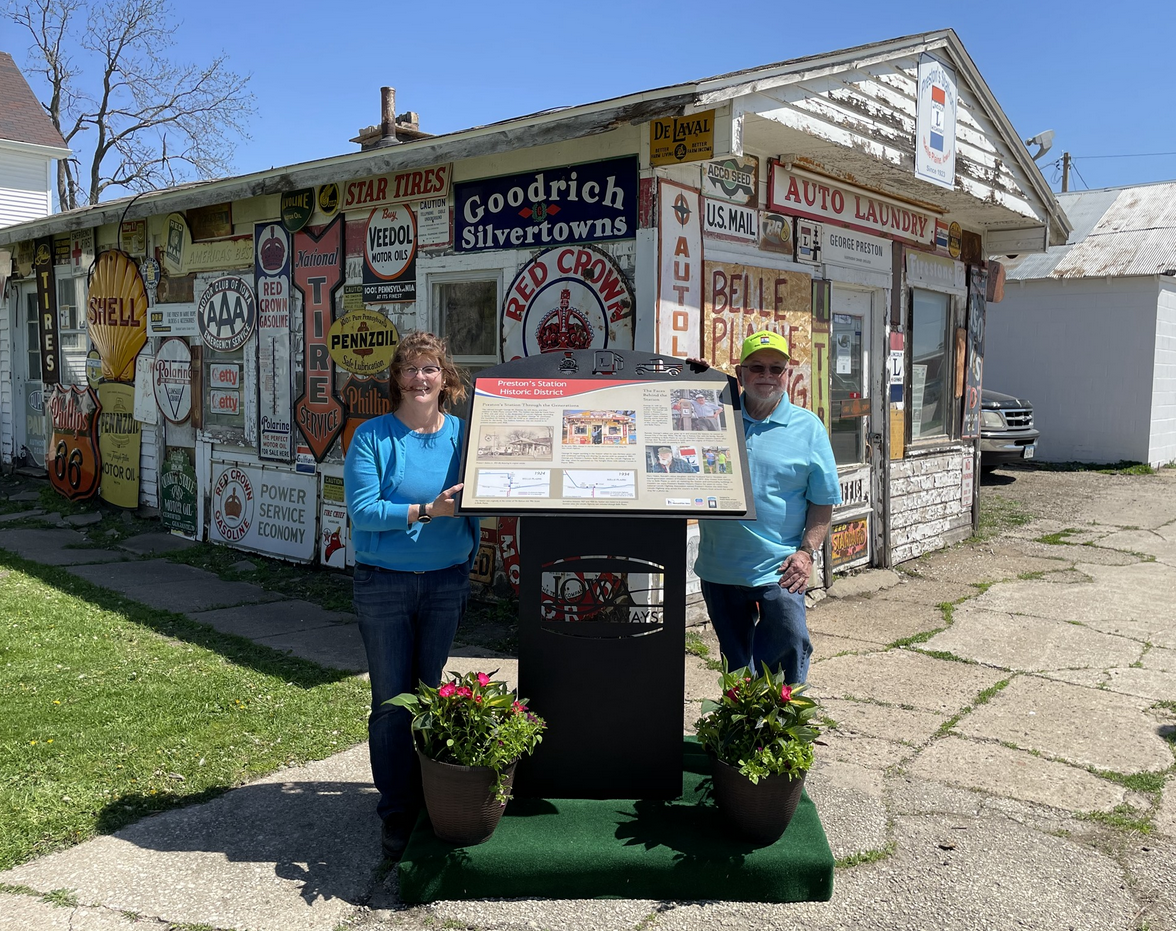
On Saturday, May 1st, Preston’s Station Historic District unveiled an interpretive panel sharing the Prestons’ history through four generations. 10 interpretive panels have been installed across Iowa on the Lincoln Highway. Preston’s was the first project to unveil an interpretive panel. According to Prestons’, their town of “Belle Plaine is the greatest little town on the Lincoln Highway in the state of Iowa.”
This semester three students from Dr. Fisanick’s @CalUofPA Honors English program created a 4.5-minute presentation about the 1919 Motor Transport Corps Convoy, which included future President Dwight Eisenhower.