Vintage Views
Postcard Scenes of the Lincoln Highway
The Closest You'll Get to the Way It Was
By George Clark
Postcards from George Clark
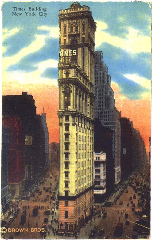
Control, Times Square, New York City, New York -- Eastern Terminus of the Lincoln Highway
So states the 1924 edition of A Complete Official Road Guide of the Lincoln Highway. While no photograph has ever surfaced of a marker announcing this fact, this is the intersection at which you would set your odometer to commence your journey westward.
 This postcard view to the south depicts the Times Building, a twenty-five-story edifice owned by the New York Times, situated on a trapezoidal parcel of ground, bordered by Broadway (veering to the left) and 7th Avenue (veering to the right), with 42nd Street crossing both avenues. Driving south on Broadway, take a right on 42nd Street and, according to the guide, travel over a paved street for 1.1 miles to the Hudson River, where you board a ferry, leaving every fifteen minutes, for Weehawken, New Jersey. In a matter a minutes, you have traversed the New York section of the Lincoln Highway. This postcard view to the south depicts the Times Building, a twenty-five-story edifice owned by the New York Times, situated on a trapezoidal parcel of ground, bordered by Broadway (veering to the left) and 7th Avenue (veering to the right), with 42nd Street crossing both avenues. Driving south on Broadway, take a right on 42nd Street and, according to the guide, travel over a paved street for 1.1 miles to the Hudson River, where you board a ferry, leaving every fifteen minutes, for Weehawken, New Jersey. In a matter a minutes, you have traversed the New York section of the Lincoln Highway.
The Times Building remains a Manhattan landmark and is a focal point of millions of viewers each New Year's Eve.
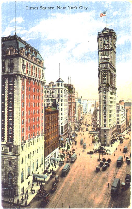
 This is another view of Times Square, looking south on Broadway (veering to the left). This card is of particular interest as it is dated April 15, 1913, exactly two and a half months prior to the organization of the Lincoln Highway Association on July 1, 1913. This scene presages the demise of horse-drawn conveyances and the emergence of motorized vehicles. This is another view of Times Square, looking south on Broadway (veering to the left). This card is of particular interest as it is dated April 15, 1913, exactly two and a half months prior to the organization of the Lincoln Highway Association on July 1, 1913. This scene presages the demise of horse-drawn conveyances and the emergence of motorized vehicles.
While Lincoln Highway travelers used the ferries at the foot of 42nd Street, the route was ultimately realigned to utilize a new form of river crossing, which would eliminate the use of ferries. Page 194 of the 1924 edition of A Complete Official Road Guide of the Lincoln Highway alludes to this change. Under the heading The Lincoln Way Vehicular Tunnel, it reads:
The two states of New York and New Jersey are now jointly building a wonderful vehicular tunnel which will when completed carry Lincoln Highway traffic under the Hudson River....
When these tunnels are completed and opened to the public, probably in 1925, the use of the Hudson River ferries will be unnecessary.
The Lincoln Highway Association writer of this particular section was somewhat optimistic, inasmuch as tunnel construction did not commence until 1930 and was not open to the public until 1937.
[James Lin: Actually, the writer was talking about the Holland Tunnel, which opened to the public in 1927. George's postcard depicts the Lincoln Tunnel, which started being built in 1934 and was completed in 1937.]
![[Postcard of Lincoln Tunnel]](thumbnails/lincoln_tunnel.jpg) This postcard depicts the tunnels from the New Jersey side of the Hudson River and was probably taken soon after it opened. In this image, it would appear that the westbound tunnel is closed as westbound traffic is using coned eastbound lanes. This postcard depicts the tunnels from the New Jersey side of the Hudson River and was probably taken soon after it opened. In this image, it would appear that the westbound tunnel is closed as westbound traffic is using coned eastbound lanes.
[James Lin: A second tube of the Lincoln Tunnel was opened in 1945, and a third tube was opened in 1957. Given the fact that the postcard shows two tubes, and judging from the styles of the cars, this photo was probably taken in the late 1940s, soon after the second tube opened.]
![[Postcard of S.S. Grand View Point Hotel in Pennsylvania]](thumbnails/grand_view_1.jpg) Perhaps the greatest oddity to be sighted on the Lincoln Highway in Pennsylvania (or perhaps along the entire Lincoln for that matter) was the S.S. Grand View Point Hotel. Clinging to the downslope side of the Lincoln as it crossed the Alleghenies, this five-story structure was remodeled to resemble a small ocean liner. Perhaps the greatest oddity to be sighted on the Lincoln Highway in Pennsylvania (or perhaps along the entire Lincoln for that matter) was the S.S. Grand View Point Hotel. Clinging to the downslope side of the Lincoln as it crossed the Alleghenies, this five-story structure was remodeled to resemble a small ocean liner.
It featured a canvas-covered observation deck on the bow and on the fantail. Life preservers were attached to the life rails, and telescopes were positioned to sweep the terrain of three states and seven counties. Note the ship is in "full dress," naval parlance for pennants streaming from bow to stern.
Aboard was a gift shop and restaurant (another card in this collection depicts the maitre'd in nautical officer attire). And, for those who might be inclined to drink and drive, there was the Coral Room Bar and Lounge. Also, overnight accomodations were available.
Looking at the postcard above, it appears that the Lincoln Highway sign remained after the highway was proclaimed U.S. 30, inasmuch as the auto in the foreground is an early 1930s model. Also, behind this sign appears to be a similar sign for the benefit of those traveling in the opposite direction. If you closely scrutinize the postcard below, you will see the back of the sign in the postcard above (look to the right of to the truck going downhill).
![[Aerial photo of S.S. Grand View Point Hotel in Pennsylvania]](thumbnails/grand_view_2.jpg) At the time this aerial photo was taken, the Lincoln had become U.S. 30. The cars in this photo tell us it may have been taken in the early 1930s. Note the non-nautical, two-pump service station cross the street. At the time this aerial photo was taken, the Lincoln had become U.S. 30. The cars in this photo tell us it may have been taken in the early 1930s. Note the non-nautical, two-pump service station cross the street.
|
![[Postcard of Lincoln Tunnel]](lincoln_tunnel.jpg)
![[Postcard of S.S. Grand View Point Hotel in Pennsylvania]](grand_view_1.jpg)
![[Aerial photo of S.S. Grand View Point Hotel in Pennsylvania]](grand_view_2.jpg)